Dominica Volcanoes
-

Morne Plat Pays
-
Morne Plat Pays
-

Morne Plat Pays
-
Morne Plat Pays
-
Morne Plat Pays
-
Morne aux Diables
-
Morne Plat Pays
-
Morne Plat Pays
-
Morne aux Diables
-
Morne Trois Pitons
-
Morne Plat Pays
-
Morne Plat Pays
-
Morne Watt
-
Morne Plat Pays
-
Morne Trois Pitons
-
Morne Plat Pays
-
Morne Diablotins
-
Morne Plat Pays
-
Morne Plat Pays
-
Morne Plat Pays
Dominica has 5 Holocene volcanoes. Note that as a scientific organization we provide these listings for informational purposes only, with no international legal or policy implications. Volcanoes will be included on this list if they are within the boundaries of a country, on a shared boundary or area, in a remote territory, or within a maritime Exclusive Economic Zone. Bolded volcanoes have erupted within the past 20 years. Suggestions and data updates are always welcome ().
| Volcano Name | Location | Last Eruption | Primary Volcano Type |
|---|---|---|---|
| Morne aux Diables | Dominica | Unknown - Evidence Credible | Lava dome(s) |
| Morne Diablotins | Dominica | Unknown - Evidence Uncertain | Stratovolcano |
| Morne Plat Pays | Dominica | 1270 CE | Stratovolcano |
| Morne Trois Pitons | Dominica | 920 CE | Complex |
| Morne Watt | Dominica | 1997 CE | Stratovolcano(es) |
Chronological listing of known Holocene eruptions (confirmed or uncertain) from volcanoes in Dominica. Bolded eruptions indicate continuing activity.
| Volcano Name | Start Date | Stop Date | Certainty | VEI | Evidence |
|---|---|---|---|---|---|
| Morne Watt | 1997 Jul 15 | 1997 Jul 15 | Confirmed | 1 | Observations: Reported |
| Morne Watt | 1880 Jan 4 | 1880 Jan 4 | Confirmed | 2 | Observations: Reported |
| Morne Plat Pays | 1270 ± 50 years | Unknown | Confirmed | Isotopic: 14C (uncalibrated) | |
| Morne Trois Pitons | 0920 ± 50 years | Unknown | Confirmed | Isotopic: 14C (uncalibrated) | |
| Morne Trois Pitons | 0790 ± 50 years | Unknown | Confirmed | Isotopic: 14C (uncalibrated) | |
| Morne Watt | 0640 ± 150 years | Unknown | Confirmed | Isotopic: 14C (uncalibrated) | |
| Morne Plat Pays | 0390 ± 40 years | Unknown | Confirmed | Isotopic: 14C (uncalibrated) | |
| Morne Plat Pays | 0430 BCE (?) | Unknown | Confirmed | Isotopic: 14C (uncalibrated) | |
| Morne Watt | 0950 BCE ± 300 years | Unknown | Confirmed | Isotopic: 14C (uncalibrated) | |
| Morne Watt | 1800 BCE ± 100 years | Unknown | Confirmed | Isotopic: 14C (uncalibrated) | |
| Morne Plat Pays | 4740 BCE (?) | Unknown | Confirmed | Isotopic: 14C (uncalibrated) |
Dominica has 4 Pleistocene volcanoes. Note that as a scientific organization we provide these listings for informational purposes only, with no international legal or policy implications. Volcanoes will be included on this list if they are within the boundaries of a country, on a shared boundary or area, in a remote territory, or within a maritime Exclusive Economic Zone. Suggestions and data updates are always welcome ().
| Volcano Name | Location | Primary Volcano Type |
|---|---|---|
| Dos Hermanos | West Indies | Volcanic field |
| Foundland | Dominica | Stratovolcano |
| San Juan | West Indies | Pyroclastic cone(s) |
| Valle Nuevo | West Indies | Volcanic field |
There are 28 photos available for volcanoes in Dominica.
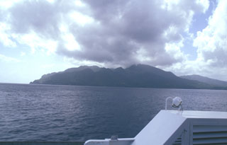
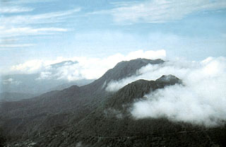
 Cloud-draped Morne Diablotins (center) is the largest volcano on Dominica and one of the largest of the Lesser Antilles. It is seen here from the south beyond Morne Trois Piton volcano at the far right. Two coalescing lava domes form the summit of 1430-m-high Morne Diablotins, and precolumbian pyroclastic-flow aprons on the NW flank are relatively unmodified by erosion. Historical eruptions are not known from Morne Diablotins. However the volcano has a youthful appearance, and seismic swarms have occurred nearby in recent years.
 Photo by Paul Jackson, 1998 (Seismic Research Unit, University of West Indies).
 Scotts Head lava dome forms a dramatic promontory marking the southern margin of Soufrière Bay and is connected by a narrow spit only a few meters high to Scotts Head village (left-center). The weathered hill (also known as Pointe Cachacrou) consists of subvertical lava sheets and is a remnant of lava dome extruded along a fracture inboard of the southern margin of the Soufrière Bay depression. The slopes of Crabier lava dome rise at the left.
Photo by Lee Siebert, 2002 (Smithsonian Institution).
 Steam rises from Boiling Lake, a geothermal area on the NE flank of Morne Watt volcano. This phreatomagmatic explosion crater is filled by a bubbling lake about 85 x 75 m wide, with a typical depth of about 10-15 m. Both water level and temperature have varied widely during historical time. The lake was almost empty following the 1880 phreatic eruption, and again temporarily almost emptied in December 2004, when water levels dropped 10 m or more below the high-water mark.
Photo by Paul Jackson, 1998 (Seismic Research Unit, University of West Indies).
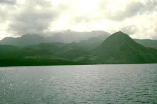
 Morne Plat Pays (left), Morne Patates (right-center) and Crabier (right) at the SW tip of Dominica are seen from the SW. The Morne Plat Pays volcanic complex contains the Morne Plat Pays stratovolcano and a complex of central lava domes. The complex is cut by a large depression, partly filled by the lava domes, that was formed by collapse of the volcano during the late Pleistocene. The collapse scarp is 400-900 m high, and submarine debris-avalanche blocks from the collapse are visible in bathymetry.
Photo by Paul Kimberly, 2002 (Smithsonian Institution).
 Morne aux Diables volcano at the northern tip of Dominica is a stratovolcano composed of andesitic lava domes, lava flows, and block-and-ash flow deposits well exposed in coastal sea cliffs. Volcanism at the dominantly Pleistocene Morne aux Diables is considered to have likely continued into the Holocene; unconsolidated block-and-ash flow deposits extend to the NW and NE coasts. Fumarolic areas are present on the volcano, and the Penville Cold Soufrière, an area of bubbling pools, lies within the youngest crater of the volcano.
 Photo by Lee Siebert, 2002 (Smithsonian Institution).
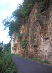 A roadcut in the Roseau River valley on the outskirts of the capital city reveals deposits of the Roseau Tuff. This thick sequence of pyroclastic flows (sometimes welded), pyroclastic surges, and pumice-lapilli airfall deposits was erupted between about 40,000 and 25,000 years ago.
 Photo by Paul Kimberly, 2002 (Smithsonian Institution).
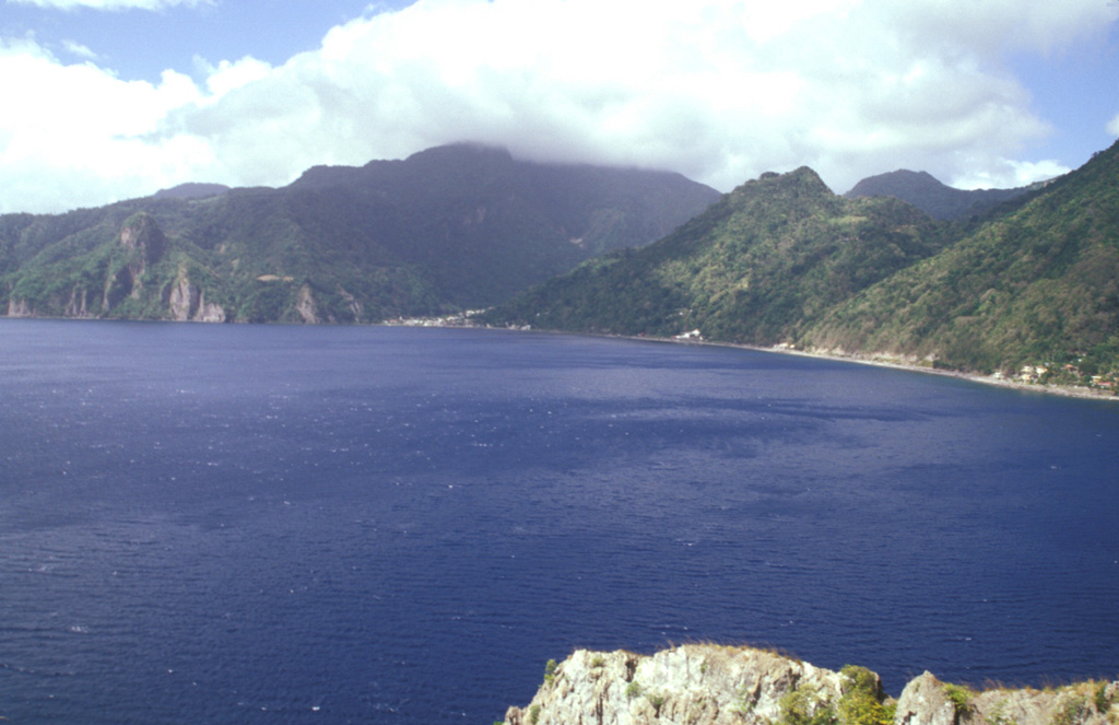
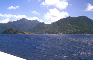
 The promontory at Scotts Head provides a vantage point overlooking the partially submerged Plat Pays caldera, widely breached to the west at Soufrière Bay. The caldera, which partially truncated Morne Plat Pays stratovolcano (in the clouds on the center horizon) formed about 39,000 years ago. Its margins extend from north of Sorcière lava dome (far left) to near Scotts Head. Morne Patates, the dome along the coast at the right-center, is the youngest post-caldera lava dome and was active until at least about 700 years ago.
Photo by Paul Kimberly, 2002 (Smithsonian Institution).
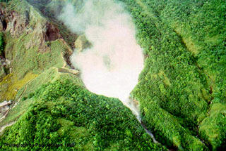
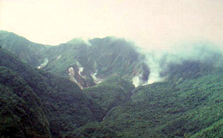 Fumarolic clouds mark the Valley of Desolation and Boiling Lake thermal areas, NE of Morne Watt (Watt Mountain) volcano in SE Dominica. The Valley of Desolation and the Boiling Lake are major tourist attractions within the national park east of Roseau. A major eruption from Morne Watt produced pyroclastic flows about 930 years ago. The only historical eruptions on the island of Dominica were a moderately large phreatic explosion at the Valley of Desolation thermal area in 1880 and a smaller phreatic explosion in July 1997.
 Photo by Paul Jackson, 1998 (Seismic Research Unit, University of West Indies).
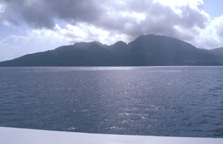
 The NW side of Morne aux Diables volcano at the northern tip of Dominica is seen from the hydrofoil ferry between Guadeloupe and Dominica. Lava domes are prominent on the 681-m-high volcano, both at the summit and its flanks. Bathymetry reveals evidence for a twin-peaked lava dome about 5 km off the NW coast that reaches to within 153 m of the sea surface. Both domes, known informally as Twin Peaks, rise more than 1000 m above the sea floor.
Photo by Paul Kimberly, 2002 (Smithsonian Institution).
 Cloud-draped Morne Diablotins volcano rises above the leeward coast of Dominica. This little known volcano is the largest on Dominica and one of the largest of the Lesser Antilles. Two coalescing lava domes form the summit of 1430-m-high Morne Diablotins, and precolumbian pyroclastic-flow aprons on the NW flank are relatively unmodified by erosion. The sharp-topped peak in the right foreground is the Morne Espagnol (Barbers Rock) lava dome. No historical eruptions are known from Morne Diablotins.
Photo by Lee Siebert, 2002 (Smithsonian Institution).
 The Morne Patates (far left) and Crabier (right) lava domes, the youngest features of the Morne Plat Pays volcanic complex, rise above Scotts Head village on the southern tip of Dominica. The youngest dated eruption from Morne Patates took place about 685 years Before Present (BP) and produced block and ash flow deposits. Similar deposits were dated at about 1560 yrs BP, and an airfall deposit dated at about 2380 yrs BP also originated from this group of young lava domes.
 Photo by Lee Siebert, 2002 (Smithsonian Institution).
 Morne aux Diables stratovolcano at the northern tip of the island of Dominica rises above beaches on the NE shore of the island near the village of Calibishie. Several nested craters and a 90-m-high, 335-m-wide lava dome are located within a larger 1.2-km-wide crater. The youngest, NW crater contains an active fumarolic area. No eruptions are known in historical time. Severe earthquake swarms in 1841 and 1893 were associated with either Morne aux Daibles or Morne Diablotins to the south.
Photo by Jan Lindsay, 2000 (Seismic Research Unit, University of West Indies)
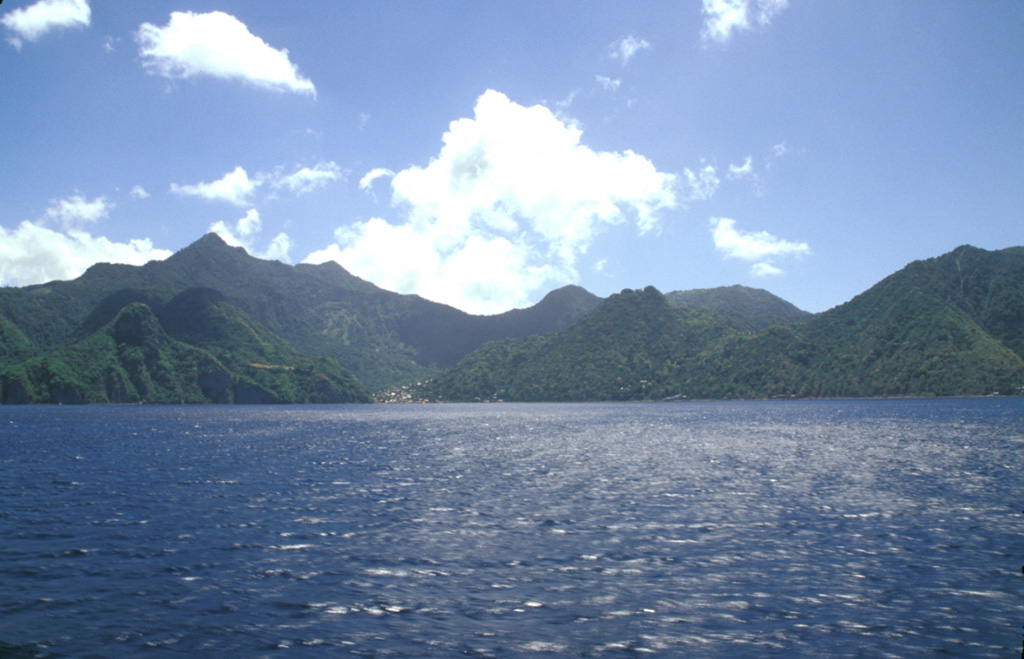
 Two large lava domes, Micotrin (lower right) and Morne Trois Pitons (upper right), are located along the margin of a large semi-circular depression on the western coast of central Dominica NE of the capital city of Roseau. The village of Laudat at the lower left lies along a road traversing the flanks of Micotrin on the way to the Atlantic coast. The most recent dated dome-forming eruption at the Trois Pitons/Micotrin complex took place about 800 CE. Morne Diablotins volcano lies in the clouds at the upper left.
 Photo by Paul Jackson, 1998 (Seismic Research Unit, University of West Indies).
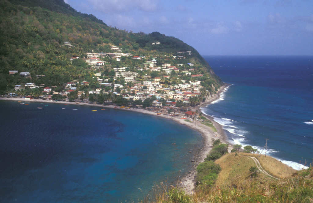
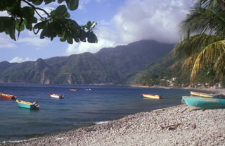
 A narrow sand-and-gravel bar connects the picturesque fishing village of Scotts Head, the southernmost on Dominica, to the Scotts Head lava dome. The village, also known as Cachacrou, overlies volcaniclastic deposits on the SW flank of Crabier lava dome, a post-caldera dome near the southern rim of the Morne Plat Pays caldera.
Photo by Lee Siebert, 2002 (Smithsonian Institution).
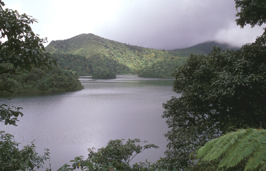
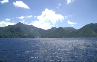
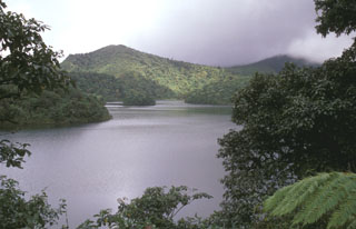 Freshwater Lake (L'Etang) lies in the moat between Micotrin lava dome and the eastern wall of the Wotten Waven caldera, partially visible in the background. The 7 x 4.5 x wide caldera is elongated in an SW-NE direction, and it extends on the SW to near the capital city of Roseau. The two coalesced lava domes of Micotrin straddle the NE rim of the caldera. Strong geothermal activity persists in the caldera, the most prominent of which lies near the village of Wotten Waven along the River Blanc and contains numerous bubbling pools and fumaroles.
Photo by Lee Siebert, 2002 (Smithsonian Institution).
 Steep-sided Morne Watt, seen here from the NW, is a lava-dome complex surrounded by block-and-ash flow deposits. The 1224-m-high volcano was constructed south of the Wotten Waven caldera and is flanked by Morne Anglais (4 km to the SW) and the Grand Soufrière Hills volcano, 3 km to the east. The renowned Valley of Depression geothermal area cuts the NE flank of Morne Watt and lies out of view to the left.
Photo by Lee Siebert, 2002 (Smithsonian Institution).
 The Sulfur Springs thermal area was the site of combustion and melting of sulfur deposits in 1994 that produced a sulfur flow over an area of about 1 km2, prompting reports of a volcanic eruption. Measured fumarole temperatures at Sulfur Springs have ranged between about 90 and 100 degrees Centigrade over the past century.
Photo by Paul Kimberly, 2002 (Smithsonian Institution).
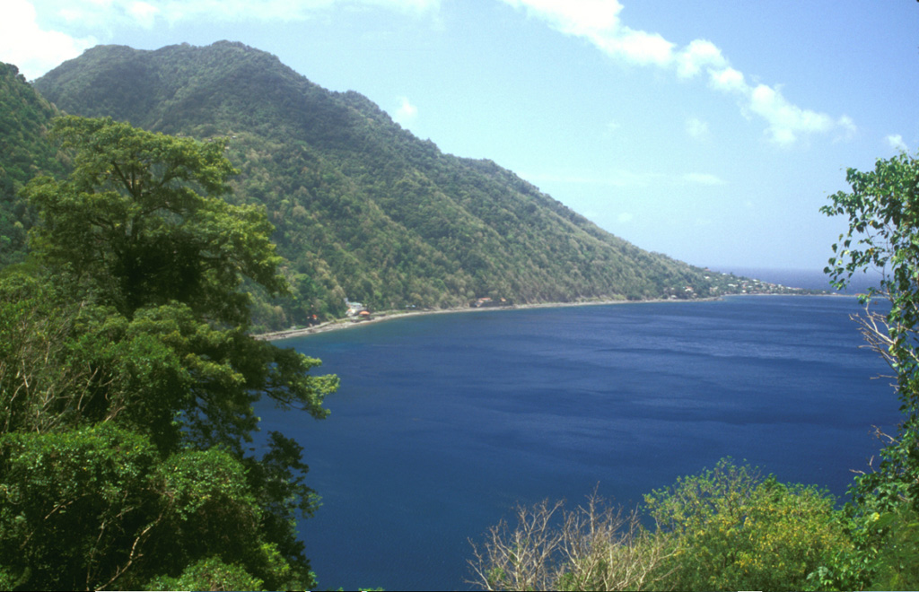
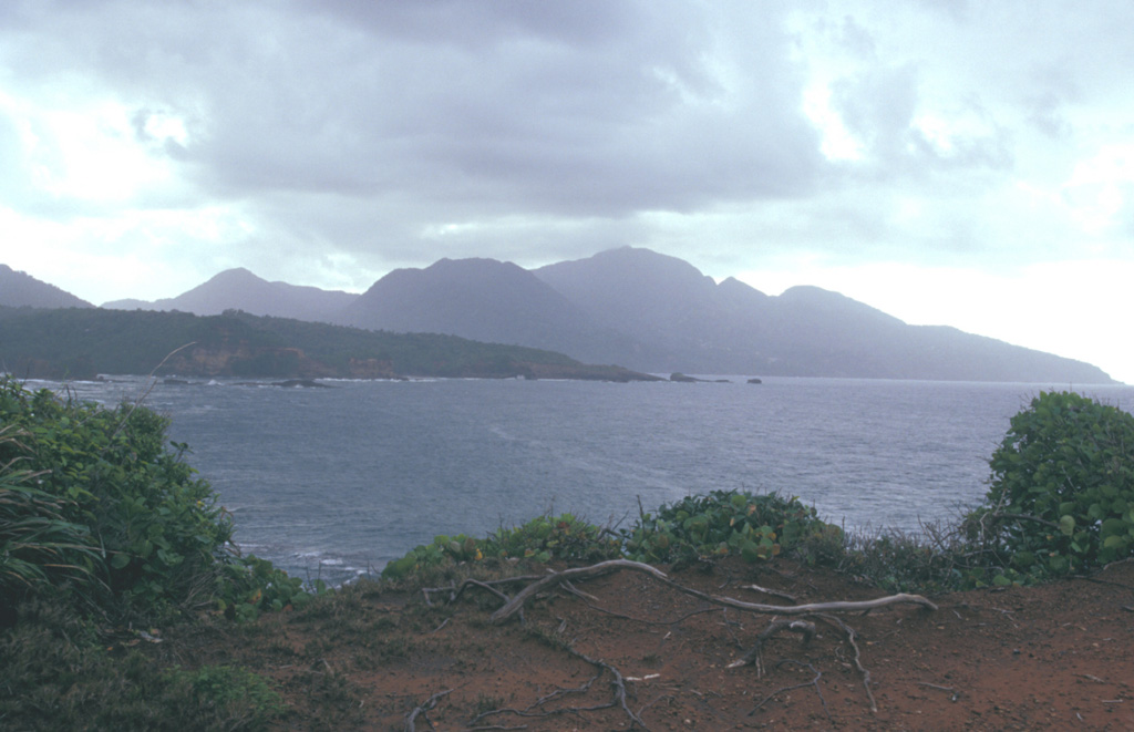
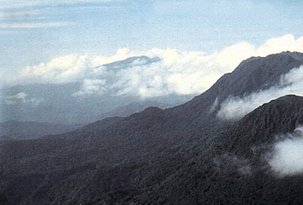
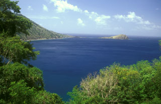
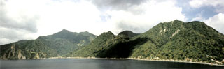 The 4-km-wide caldera of the Morne Plat Pays volcanic complex is widely breached to the sea of the west in this view from Scotts Head lava dome. It formed about 39,000 years ago following a major plinian explosive eruption and flank collapse that truncated Morne Plat Pays stratovolcano, the peak on the left-center horizon. The northern caldera margin lies immediately north of the post-caldera Socrière lava dome at the far left and near Soufrière village at the far right. Post-caldera lava domes form the center-to-right horizon.
Photo by Jan Lindsay, 2000 (Seismic Research Unit, University of West Indies).
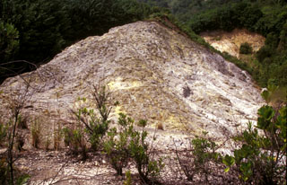
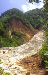 The upper Sulphur Springs geothermal area cuts the SW flank of Morne Plat Pays stratovolcano and lies just inside the large scarp formed by collapse of the edifice. The thermal area consists of steaming, hydrothermally altered ground with yellowish area marking many sulfur-encrusted fumaroles with temperatures of from 90-100 degrees Centigrade measured during the past century. Minor hot springs are also present.
 Photo by Lee Siebert, 2002 (Smithsonian Institution).
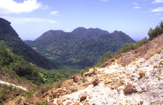 The youngest cluster of lava domes of the Morne Plat Pays volcanic complex, Morne Rouge, Crabier, and Morne Patates (left to right) is seen here from the north at the upper Sulfur Springs thermal area. The cliff in the shadow at the left is the west-facing wall of the arcuate Morne Plat Pays caldera, which formed about 39,000 years ago in association with the eruption of the Grand Bay Ignimbrite and a lateral flank collapse to the west.
Photo by Paul Kimberly, 2002 (Smithsonian Institution).
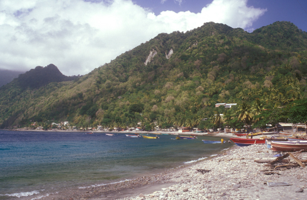
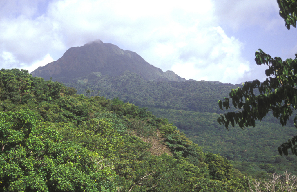
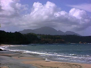
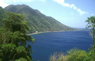
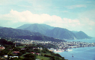 The cloud-capped summit of Morne Plat Pays stratovolcano lies on the horizon near the southern tip of the island of Dominica beyond the sprawling capital city of Roseau. Three post-caldera lava domes (left-center to right) were formed north of a large arcuate depression open to the west that formed about 39,000 years ago. The latest dated eruption at the Morne Plat Pays volcanic complex occurred from the Morne Patates lava dome about 1270 CE, although younger deposits have not yet been dated.
 Photo by Paul Jackson, 1998 (Seismic Research Unit, University of West Indies).
 The Crabier lava dome rises about 500 m above the western shores of Soufrière Bay, with Scotts Head village at the far right. The dome is one of the youngest post-caldera features of the Morne Plat Pays volcanic complex. The Galion thermal area lies in the saddle (upper left) between Crabier and the Morne Patates lava dome.
Photo by Lee Siebert, 2002 (Smithsonian Institution).
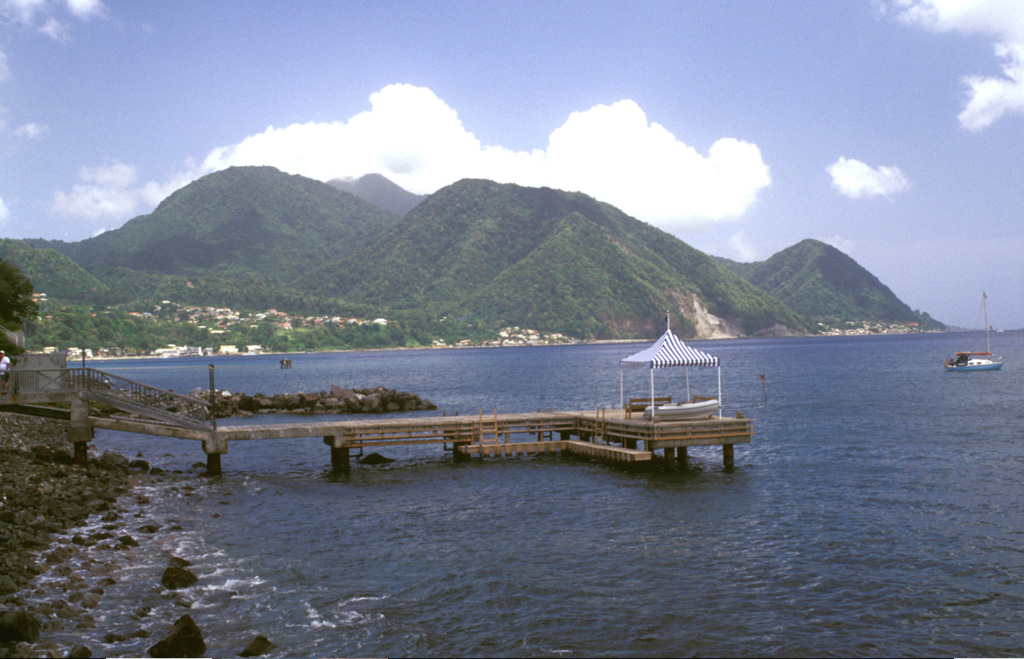
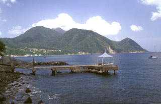
 Volcano eco-tourism is a major component of the economy of the island of Dominica. The cruise ship Queen Elizabeth II anchors in Roseau harbor with Morne Plat Pays volcano in the background. The Valley of Desolation thermal area is a popular destination for island visitors.
Photo by Lee Siebert, 2002 (Smithsonian Institution).
 Morne aux Diables volcano rises above the Atlantic coast of NW Dominica. The summit of the volcano is formed by a complex of lava domes, and flank domes, which extend in a roughly E-W chain across the southern flank of the volcano, are visible on the left horizon.
 Photo by Paul Kimberly, 2002 (Smithsonian Institution).
 The Plat Pays volcanic complex rises to the south beyond the shoreline of the city of Roseau in the foreground. Three lava domes that formed after the roughly 39,000-year-old caldera collapse at Plat Pays lie on the horizon. On the left is the rounded Morne Canot dome, in the center is La Falaise dome, and the peak at the far right is Morne la Vue, which rises above the village of Pointe Michel. The summit of the Morne Plat Pays stratovolcano lies in the left-center background between Morne Canot and La Falaise domes.
Photo by Lee Siebert, 2002 (Smithsonian Institution).
 Morne Espagnol, also known as Barbers Block, is a steep-sided Pliocene lava dome that rises to 365 m above the coast on the NW flank of Morne Diablotins volcano, whose summit is hidden in the clouds. The massive volcano, the largest on Dominica, is capped by a complex of at least five lava domes. Block-and-ash flow deposits radiate away from the summit and reach the coast.
 Photo by Lee Siebert, 2002 (Smithsonian Institution).
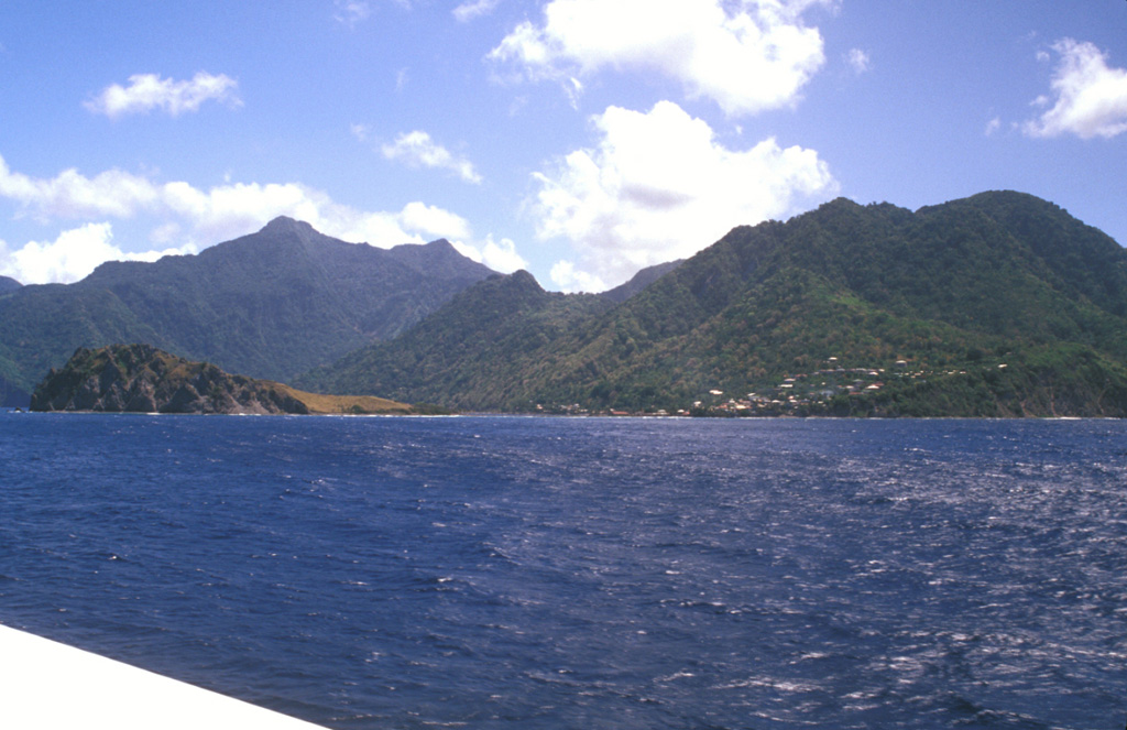
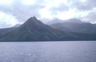
 The summit of the steep-sided Sorcière lava dome rises from the coast at the left to just above the horizon. Morne Acouma lava dome (left-center) lies to the right of Sorcière in this view from Soufrière harbor (south of the domes) and was the source of a lava flow that extends to the northern edge of the town. Coastal cliffs below the domes consist of block and ash flow deposits associated with growth of the domes. The dacitic Morne Acouma dome is older than about 28,500 years.
Photo by Lee Siebert, 2002 (Smithsonian Institution).
 Scotts Head lava dome (left foreground) forms a narrow peninsula extending from the village of Scotts Head (right) on the southern tip of Dominica. A submarine lava dome, named Mountain Top, is thought to be less than 9000 years old and rises to within 30 m of the sea surface about a kilometer south of Scotts Head dome. The peak on the left horizon is Morne Play Pays stratovolcano; the post-caldera lava domes of Morne Patates, Crabier, and Morne Rouge form the center-to-right horizon.
 Photo by Lee Siebert, 2002 (Smithsonian Institution).
This is a compilation of Dominica volcano information sources, such as official monitoring or other government agencies.
| Volcanic Ash Advisory Center | |
|---|---|
| Washington Volcanic Ash Advisory Center (VAAC) | |
| - Washington VAAC Archive | |
| - Washington VAAC Notices | |